Lesson presentation on astronomy celestial sphere. Presentation on the topic "celestial coordinate systems"
Lesson 3 Celestial coordinates
Celestial equator and celestial meridian
Equatorial coordinate system
Horizontal and equatorial coordinates
The culmination of the luminaries

Due to the axial rotation of the Earth, the stars appear to us moving across the sky.
concentric arcs in the photo - traces of the paths of stars
It is convenient to study the phenomena of the daily motion of stars using the mathematical construction - celestial sphere

Celestial sphere - an imaginary sphere of arbitrary radius onto which heavenly bodies are projected
The observer's eye is usually taken as the center of the celestial sphere.
For an observer on the surface of the Earth, the rotation of the celestial sphere reproduces the daily movement of the luminaries in the sky

For ancient peoples:
the presence of a real sphere that limits the whole world and carries numerous stars on its surface
Center of the celestial sphere:
- where the observer is located (topocentric celestial sphere),
- to the center of the Earth (geocentric celestial sphere),
- to the center of a particular planet (planet-centric celestial sphere),
- to the center of the Sun (heliocentric celestial sphere) or to any other point in space.

Plumb line (or vertical line)
- a straight line passing through the center of the celestial sphere and coinciding with the direction of the plumb line at the observation point
The plumb line intersects with the surface of the celestial sphere at two points - zenith e, above the observer's head, and nadir e - diametrically opposite point
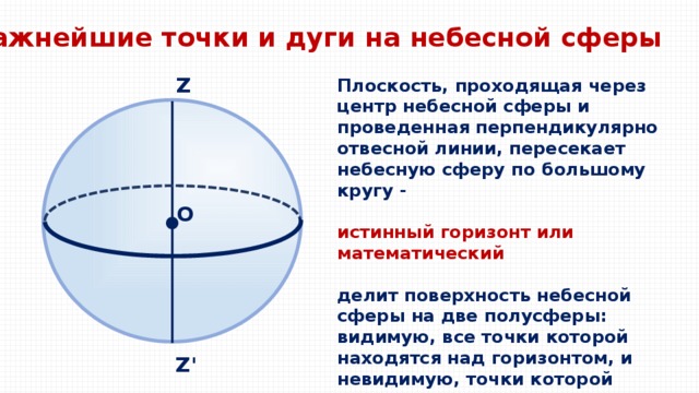
The most important points and arcs on the celestial sphere
A plane passing through the center of the celestial sphere and drawn perpendicular to the plumb line intersects the celestial sphere in a great circle -
true horizon or mathematical
divides the surface of the celestial sphere into two hemispheres: the visible, all points of which are above the horizon, and the invisible, the points of which lie below the horizon

The most important points and arcs on the celestial sphere
world axis
world axis - axis of apparent rotation of the celestial sphere
The axis of the world intersects the celestial sphere at two points P and P ₁ - pole Oh peace
Near the north pole of the world is currently located α Ursa Minor - the North Star

The most important points and arcs on the celestial sphere
Celestial equator - a large circle of the celestial sphere, the plane of which is perpendicular to the axis of the world.
The celestial equator divides the surface of the celestial sphere into two hemispheres:
northern hemisphere, with a peak at the north celestial pole,
and southern hemisphere, with apex at the south celestial pole
Celestial equator
The celestial equator intersects the mathematical horizon at two points: the east point and the west point. East point E- the point at which the points of the rotating celestial sphere cross the mathematical horizon, passing from the invisible to the visible hemisphere
W - west point

The most important points and arcs on the celestial sphere
sky meridian - a large circle of the celestial sphere, the plane of which passes through the plumb line and the axis of the world.
The celestial meridian divides the surface of the celestial sphere into two hemispheres -
the eastern hemisphere, with the apex at the east point, and
western hemisphere, apex at point west
sky meridian

The most important points and arcs on the celestial sphere
noon line - the line of intersection of the plane of the celestial meridian and the plane of the mathematical horizon
noon line
The celestial meridian intersects with the mathematical horizon at two points: north point and south point . The north point is the one that is closest to the north pole of the world
NS- noon line (objects illuminated by the Sun cast a shadow in this direction at noon)

The most important points and arcs on the celestial sphere
A small circle of the celestial sphere, the plane of which is parallel to the plane of the celestial equator - celestial or diurnal parallel luminaries M
The visible daily movements of the luminaries are made along the daily parallels
The large semicircle of the celestial sphere, passing through the poles of the world and through the star M, is called hour circle or declination circle luminaries
The large semicircle of the celestial sphere, passing through the zenith, the luminary M and the nadir, is called height circle,
vertical circle or vertical
luminaries

The most important points and arcs on the celestial sphere
Ecliptic
Ecliptic - the trajectory of the apparent annual movement of the Sun in the celestial sphere.
Ecliptic
The plane of the ecliptic intersects with the plane of the celestial equator at an angle
ε = 23°26".

The most important points and arcs on the celestial sphere
The ecliptic intersects with the celestial equator at two points - spring and autumn equinoxes
At the point of the vernal equinox (♈) the Sun moves from the southern hemisphere of the celestial sphere to the northern one, at the point of the autumnal equinox (♎) - from the northern hemisphere of the celestial sphere to the southern
The line passing through these two points is equinoctial line
♈ - sign of Aries ♎ - sign of Libra

The most important points and arcs on the celestial sphere
Two points of the ecliptic, 90 ° away from the equinoxes and as far as possible from the celestial equator - the solstice points
Summer Solstice Point (♋)
located in the northern hemisphere
winter solstice point (♑)
in the southern hemisphere
♑ - sign of Capricorn ♋ - sign of Cancer

The main plane is plane of the celestial equator
Coordinate declination δ luminaries M - arc mM of the hour circle PMmP "from the celestial equator to the luminary
or central corner mOM (in the plane of the hour circle).
Q ΄
Measured within the range from 0° to +90° to the north celestial pole and from 0° to -90° to the south celestial pole
P ΄
Z ΄
Sometimes the declension is replaced polar distance p(also either arc PM or central angle ROM). They are counted from 0° to 180° from the north celestial pole to the south. p+ δ = 90°

First equatorial coordinate system
Second coordinate - hour angle t luminaries M - the arc of the celestial equator Qm from the upper point Q of the celestial equator to the hour circle PMmP "passing through the luminary,
or central angle QOm (in the plane of the celestial equator)
Hourly angles are measured in the direction of the daily rotation of the celestial sphere, i.e. west of the highest point Q of the celestial equator, ranging from 0° to 360° or from 0 ʰ up to 24 ʰ
Q ΄
P ΄
Z ΄
In the process of daily rotation of the celestial sphere, the declination δ of the luminaries
do not change (if we neglect the proper motion of the stars), and the hourly angles t increase.

Second equatorial coordinate system
One coordinate declination δ , other right ascension α
Right ascension α of the star M - the arc of the celestial equator ♈m from the vernal equinox ♈ to the hour circle passing through the star
or central angle ♈Оm (in the plane of the celestial equator)
Q ΄
It is counted in the direction opposite to the daily rotation in the range from 0° to 360° or from 0 ʰ up to 24 ʰ
P ΄
Z ΄
The system is used for determining star coordinates and compiling catalogs. Determines the annual movement of the Sun and other luminaries.

Horizontal coordinate system
The main plane is mathematical horizon plane
One coordinate - zenith distance z, or the height of the star above the horizon h
The height h of the luminary M is the arc of the vertical circle mM from the mathematical horizon to the luminary
Q ΄
or central angle mOM
Heights are measured within the range from 0° to +90° (toward the zenith) and from 0° to -90° (to the nadir)
P ΄
Z ΄
The zenith distance z of the luminary M is the arc of the vertical circle ZM from the zenith to the luminary or the central angle ZOM. Zenith distances are counted from 0° to 180° in the directions from zenith to nadir. z + h = 90°

Horizontal coordinate system
Second coordinate - azimuth A
- the arc of the mathematical horizon Sm from the south point S to a vertical circle passing through the luminary
or the central angle SOm (in the plane of the mathematical horizon)
Q ΄
Azimuths are measured in the direction of the daily rotation of the celestial sphere, i.e., west of the south point S, ranging from 0 ° to 360 °
P ΄
Z ΄
The coordinate system is used to directly determine the apparent positions of the luminaries using goniometric tools.

Definition of geographic latitude
Angle (height of the world pole above the horizon
) is equal to the angle (geographical latitude of the place φ ),
as angles with mutually perpendicular sides OS ⟘ CN; OR⟘CP
The equality of these angles gives simplest way determining the geographical latitude of the area: the angular distance of the pole of the world from the horizon is equal to the geographical latitude of the area
To determine the geographic latitude of the area, it is enough to measure the height of the celestial pole above the horizon:
= φ

At the pole of the earth
the celestial pole is at its zenith and the stars move in circles parallel to the horizon
Here the stars do not set or rise,
their height above the horizon is unchanged

Daily movement of luminaries at different latitudes
At middle geographic latitudes
there are ascenders and
setting stars and those that never sink below the horizon
circumpolar constellations
at the geographical latitudes of Russia never enter
Constellations lying near the south celestial pole are non-ascending.

Daily movement of luminaries at different latitudes
At the equator, all stars rise and set perpendicular to the horizon.
Each star here passes above the horizon exactly half of its path.
The north celestial pole coincides with the north point, and the south celestial pole coincides with the south point.
The axis of the world is located in the plane of the horizon

The height of the luminaries at the climax
climaxes - phenomena of the passage of luminaries through the celestial meridian
In the upper climax, the height of the luminary is maximum,
in the lower culmination - is minimal.
The time interval between climaxes is half a day
The moment of the upper culmination of the center of the Sun - true noon ,
the moment of the lower culmination - true midnight

The height of the luminaries at the climax
At not setting at a given latitude φ of the luminaries, both culminations are visible (above the horizon),
at the stars that rise and fall , the lower climax occurs below the horizon.
For a luminary far south of the celestial equator, both culminations may be invisible (luminary not ascending )

h - the height of the luminary M at the upper climax
δ - declination of the luminary
φ - latitude
∠ PON==φ
∠ QOZ = ∠PON as angles with mutually perpendicular sides
90°-φ
h = 90° - φ + δ
Geographic latitude can be determined by measuring the height of any luminary with a known declination δ at the top culmination
Q ʹ
At the bottom climax: -h = 90° - φ - δ or
h = δ + φ - 90°
P ʹ
Z ʹ

Determine the geographical latitude of the observation site if the star Vega passes through the zenith point.
Given:
δ = +38°47 ′
h = 90°
h = 90° - φ + δ
φ = 90° - h + δ
φ = 90° - 90° + 38°47 ′ = 38°47 ′
Sirius was at the top climax at 10°. What is the latitude of the observation site?
h = 90° - φ + δ
Given:
δ = -16°39 ′
φ = 90° - h + δ
φ = 90° - 10° + (-16°39 ′) = 63°21 ′


 Back forward
Attention! The slide preview is for informational purposes only and may not represent the full extent of the presentation. If you are interested this work please download the full version.
The purpose of the lesson: to introduce students to stellar coordinates, to instill the skills of determining these coordinates on a model of the celestial sphere.
Equipment: video projector, celestial sphere layout
During the classes
Teacher: Since time immemorial, people have identified separate groups of bright stars in the starry sky, united them into constellations, giving them names that reflect their way of life and the peculiarities of their thinking. So did the ancient Chinese, Babylonian, Egyptian astronomers. Many of the constellation names we use today come from Ancient Greece, where they evolved over the centuries.
Table 1 Chronicle of names
At the congress of the International Astronomical Union in 1922, the number of constellations was reduced to 88. At the same time, the current boundaries between them were established.
should be highlighted. That the neighborhood of stars in the constellations is apparent, so they are seen by an observer from the Earth. In fact, the stars lag behind each other at great distances, and for us their visibility is, as it were, projected onto celestial sphere- an imaginary transparent ball, in the center of which is the Earth (observer), on the surface of which all the luminaries are projected as they are seen by the observer at a certain point in time from a certain point in space. Presentation.Slide 1
Moreover, the stars in the constellations are different, they differ in apparent size and light. The brightest stars in the constellations are denoted by the letters of the Greek alphabet in descending order (a, b, g, d, e, etc.) of brightness.
This tradition was introduced by Alessandro Piccolomini (1508-1578), and consolidated by Johann Bayer (1572-1625).
Then John Flamsteed (1646–1719) designated the stars within each constellation by a serial number (for example, the star 61 Cygnus). Stars with variable brightness are denoted by Latin letters: R, S, Z, RR, RZ, AA.
Now we will consider how the location of the luminaries in the sky is determined.
Imagine the sky as a giant globe of arbitrary radius, in the center of which is the observer.
However, the fact that some luminaries are located closer to us, while others are further away is not captured by the eye. Therefore, suppose that all stars are at the same distance from the observer - on the surface celestial sphere. Presentation.Slide 1
Since the stars change their position during the day, we can conclude that the celestial sphere rotates daily (this is due to the rotation of the Earth around its axis). The celestial sphere rotates around some axis PP` from east to west. The axis of apparent rotation of the sphere is the axis of the world. It coincides with the earth's axis or parallel to it. The axis of the world intersects the celestial sphere at points P - north pole of the world and P`- south pole of the world. Near the north pole of the world is the North Star (a Ursa Minor). Using a plumb line, we determine the vertical and depict it in the drawing. Presentation.Slide 1
This straight line ZZ` is called plumb line. Z- zenith, Z`- nadir. Through the point O - the intersection of the plumb line and the axis of the world - we draw a straight line perpendicular to ZZ`. This is NS- noon line(N- north, S south). In the direction along this line, objects illuminated by the Sun at noon cast a shadow.
Two mutually perpendicular planes intersect along the noon line. A plane perpendicular to a plumb line that intersects the celestial sphere in a great circle is true horizon. Presentation.Slide 1
The plane perpendicular to the true horizon, passing through the points Z and Z`, is called celestial meridian.
We have drawn all the necessary planes, now we introduce another concept. Let us place a star arbitrarily on the surface of the celestial sphere M, draw through the points Z and Z` and M big semicircle. This - height circle or vertical
The instantaneous position of the star relative to the horizon and the celestial meridian is determined by two coordinates: height(h) and azimuth(A). These coordinates are called horizontal.
The height of the luminary is the angular distance from the horizon, measured in degrees, minutes, seconds of arc, ranging from 0° to 90°. More height are replaced by an equivalent coordinate - z - zenith distance.
The second coordinate in the horizontal system A is the angular distance of the star's vertical from the south point. It is defined in degrees minutes and seconds from 0° to 360°.
Notice how the horizontal coordinates change. Light M during the day describes a daily parallel on the celestial sphere - this is a circle of the celestial sphere, the plane of which is perpendicular to axes of the world.
<Отработка навыка определения горизонтальных координат на небесной сфере. Самостоятельная работа учащихся>
When a star moves along the daily parallel, the highest point of ascent is called top climax. Moving under the horizon, the luminary will be at a point that will be a point lower climax. Presentation.Slide 1
If we consider the path of the star we have chosen, then we can see that it is ascending - setting, but there are non-setting and non-rising luminaries. (Here, relative to the true horizon.)
Consider the change in the appearance of the starry sky during the year. These changes are not so noticeable for most stars, but they do occur. There is a star in which the position changes quite a lot, this is the Sun.
If we draw a plane through the center of the celestial sphere and perpendicular to the axis of the world PP`, then this plane will intersect the celestial sphere in a great circle. This circle is called celestial equator. Presentation.Slide 2
This celestial equator intersects with the true horizon at two points: east (E) and west (W). All diurnal parallels are parallel to the equator.
Now let's draw a circle through the poles of the world and the observed luminary. The result was a circle - a circle of declination. The angular distance of the luminary from the plane of the celestial equator, measured along the circle of declination, is called the declination of the luminary (d). Declination is expressed in degrees, minutes and seconds. Since the celestial equator divides the celestial sphere into two hemispheres (northern and southern), the declination of stars in the northern hemisphere can vary from 0° to 90°, and in the southern hemisphere - from 0° to -90°.
The declination of the luminary is one of the so-called equatorial coordinates.
The second coordinate in this system is right ascension (a). It is analogous to geographic longitude. Right ascension is counted from the vernal equinox (g). The sun is at the vernal equinox on March 21st. Right ascension is measured along the celestial equator in the direction opposite to the daily rotation of the celestial sphere. Presentation.Slide 2. Right ascension is expressed in hours, minutes and seconds of time (from 0 to 24 h) or in degrees, minutes and arc seconds (from 0° to 360°). Since the position of the stars relative to the equator does not change during the movement of the celestial sphere, equatorial coordinates are used to create maps, atlases and catalogs.
Since ancient times, it has been noticed that the Sun moves among the stars and describes a full circle in one year. The ancient Greeks called this circle ecliptic, which has been preserved in astronomy to this day. Ecliptic inclined to the plane of the celestial equator at an angle of 23°27` and intersects with the celestial equator at two points: the spring equinox (g) and the autumn equinox (W). The Sun travels the entire ecliptic in a year, it travels 1° per day.
The constellations through which the ecliptic passes are called zodiacal. Every month the Sun moves from one constellation to another. It is virtually impossible to see the constellation in which the Sun is located at noon, since it outshines the light of the stars. Therefore, in practice, at midnight we observe the zodiacal constellation, which is above all above the horizon, and from it we determine the constellation where the Sun is at noon (Fig. 14 of the textbook Astronomy 11).
It should not be forgotten that the annual movement of the Sun along the ecliptic is a reflection of the actual movement of the Earth around the Sun.
Consider the position of the Sun on the model of the celestial sphere and determine its coordinates relative to the celestial equator (repetition).
<Отработка навыка определения экваториальных координат на небесной сфере. Самостоятельная работа учащихся>
Homework.
- Know the content of paragraph 116 of the Physics-11 textbook
- Know the content of paragraphs 3, 4 of the textbook Astronomy -11
- Prepare material on the topic “Zodiac constellations”
Literature.
- E.P. Levitan Astronomy Grade 11 - Enlightenment, 2004
- G.Ya.Myakishev and others. Physics Grade 11 - Enlightenment, 2010
- Encyclopedia for children Astronomy - ROSMEN, 2000

Checking d.z
- How many constellations are there in the sky? Write down the name of the circumpolar constellations you know. Draw its view of any circumpolar constellation. What letter denotes the brightest star in the constellation? Which constellation contains the North Star? Name the brightest star in the sky. What characterizes a star in the sky, depending on the apparent brightness. How to determine the direction to the north? What is the ecliptic. How many zodiac constellations are there? What about zodiac signs?
- How many constellations are there in the sky?
- Write down the name of the circumpolar constellations you know.
- Draw its view of any circumpolar constellation
- What letter represents the brightest star in the constellation?
- Which constellation contains the North Star?
- Name the brightest star in the sky.
- What characterizes a star in the sky, depending on the apparent brightness.
- How to determine the direction to the north?
- What is the ecliptic.
- How many zodiac constellations are there? What about zodiac signs?

Practical work#1
Constellation
Constellation diagram, alpha
Big Dipper
Constellation
Ursa Minor
constellation diagram
Cassiopeia
Auriga

Practical work#1
- Using a star map, enter constellation diagrams with bright stars into the appropriate columns of the table. In each constellation, highlight the brightest star and write its name.
Constellation
Constellation diagram, alpha
Big Dipper
Ursa Minor
Constellation
polar Star
Cassiopeia
constellation diagram
Auriga


Mirfak(Alpha Perseus / α Per) is the brightest star in the constellation Perseus. Translated from Arabic Mirfak as-Suraya- elbow,

Shedar(Alpha Cassiopeia)


Chapel(α Aur / α Aurigae / Alpha Aurigae)

Working with a mobile map of the starry sky
- 1. What constellations will be visible on February 17 at 10 p.m.
- 2. Will the constellation of Orion be visible on March 30 at midnight.
- 3. Is it possible to see the constellation Virgo on the night of February 17-18?


The position of a point on Earth is uniquely determined by geographical coordinates - longitude (λ) and latitude (φ).
The position of the star in the sky is uniquely determined by equatorial coordinates - right ascension (α) and declination (δ)


Basic points and lines
- Celestial sphere - an imaginary sphere of arbitrary radius, described around an observer on Earth, on the inner surface of which luminaries are applied.
- The axis of the world is the axis around which the Earth rotates, moving in world space
- The poles of the world are the imaginary axis of the visible rotation of the celestial sphere.
- celestial equator called a great circle perpendicular to the axis of the world. heavenly meridian called the great circle of the celestial sphere, passing through the celestial pole R, the south celestial pole R".


Equatorial coordinate system - the system used to determine the stellar coordinates and compiling catalogs. Determines the annual movement of the Sun and other luminaries.
- declination-arc mm hour circle from the celestial equator to the luminary. They are counted from 0 to +90 to the north pole and from 0 to -90 to the south. p+=90.
- Right ascension α- called the arc of the celestial equator ♈ from the point spring equinox♈ to the hour circle passing through the luminary (counterclockwise) from 0 to 360 or from 0 to 24 hours.

The position of the star X is indicated by coordinates - right ascension α (angular distance along the celestial equator from the vernal equinox point ϓ to the direction to the star) and declination δ (angular distance from the celestial equator along the great circle passing through the poles of the world).
Right ascension is measured in hours and can only be a positive value, declination is in degrees and can take both positive and negative values.

The magnitude of the right ascension of the same luminary does not change due to the daily rotation of the sky and does not depend on the place of observation on the surface of the Earth.
Due to the Earth's rotation, 15° corresponds to 1 hour and 1° to 4 minutes, so a right ascension of 12 hours is 180° and 7 hours 40 minutes is 115°.


The equatorial coordinates of the stars do not change for centuries,
so the equatorial coordinate system is used
when creating star globes, maps and atlases.
On a star globe, not only stars are depicted,
but also a grid of equatorial coordinates.


- Alpha southern fish
- betta andromeda
- Alpha Taurus (Aldebaran)
- Alpha Libra


Horizontal coordinate system used for direct determination of the apparent positions of the luminaries using goniometric instruments
h - height- the angular distance of the luminary from the horizon (Р MOA, measured in degrees, minutes, seconds; from 0 o to 90 o)
A - azimuth is the angular distance of the luminary's vertical from the south point (Ð SOА) in the direction of the luminary's daily motion, i.e. clockwise; It is measured in degrees minutes and seconds from 0° to 360°).


climax - the phenomenon of crossing the heavenly meridian by the luminary
- According to the daily movement of the luminaries are divided into:
- 1 - non-ascending
- 2 - (ascending - setting ) ascending and setting
- 3 - non-approaching .

Practical work №2
Spica -a Virgo +1.04

- What is the celestial sphere?
- What lines and points of the celestial sphere do you know?
- What observations prove the daily rotation of the celestial sphere (does this serve as proof of the rotation of the Earth around its axis).
- Is it possible, using a horizontal coordinate system, to create maps of the starry sky?
- What is a climax?
- Based on the climax, give the concept of non-setting, not ascending, - ascending-setting luminaries.

House. Exercise
- par.4, learn the main points and lines of the celestial sphere, coordinate systems

Celestial sphere
When we observe the sky, all astronomical objects appear to be located on a dome-shaped surface, in the center of which the observer is located.
This imaginary dome forms the upper half of an imaginary sphere, which is called the "celestial sphere".

Elements of the celestial sphere

P - the north pole of the world
True horizon
N - north point
S - south point
sky meridian
P ' - the south pole of the world
noon line
Z' - nadir

The celestial sphere plays a fundamental role in indicating the position of astronomical objects.
Horizontal coordinates
In the horizontal coordinate system, the position of an object is defined relative to the horizon and relative to the south direction (S).

Vertical - height circle

Horizontal coordinates
The position of the star M is given by its height h (angular distance from the horizon along the great circle - vertical) and azimuth A (measured to the west, the angular distance from the south point to the vertical).
Height changes: from 0 ° up to +90 ° (above the horizon) from 0 ° up to -90 ° (under the horizon)
Azimuth changes: from 0 ° up to 360 °

Culminations of heavenly bodies
Moving around the axis of the world, the luminaries describe daily parallels.
The culmination is the passage of the luminary through the celestial meridian.


Culminations of heavenly bodies
During the day, there are two climaxes: the upper and lower
The non-setting luminary has both climaxes above the horizon. The non-rising luminary has both climaxes below the horizon.

But for some tasks of astronomy, the coordinate system must be independent of the position of the observer and the time of day. Such a system is called "equatorial".
Equatorial coordinates
Due to the rotation of the Earth, the stars are constantly moving relative to the horizon and cardinal points, and their coordinates in the horizontal system change.

Celestial equator
declination
α - right ascension
vernal equinox point
Declension circle

Equatorial coordinates
Ecliptic - the apparent path of the Sun in the celestial sphere.

Equatorial coordinates
The "declination" of a star is measured by its angular distance north or south of the celestial equator.
"Right Ascension" is measured from the vernal equinox to the declination circle of a star.
"Right Ascension" changes from 0 ° up to 360 ° or from 0 to 24 hours.

Ecliptic
The Earth's axis of rotation is inclined by about 23.5° relative to the perpendicular drawn to the plane of the ecliptic.
The intersection of this plane with the celestial sphere gives a circle - the ecliptic, the apparent path of the Sun in a year.

Ecliptic
Every year in June, the Sun rises high in the sky in the Northern Hemisphere, where the days become long and the nights short.
Having moved to the opposite side of the orbit in December, in our north, the days become short and the nights long.

Ecliptic
The entire ecliptic is covered by the Sun in a year, moving 1 ° , having visited each of the 12 zodiac constellations for a month.
Astronomy lesson
Topic: "Celestial coordinates" ( routing lesson)
| Item | Astronomy |
| Class | 10 |
| Lesson topic | Celestial coordinates |
| Astronomy. 10-11. A basic level of. V. M. Charugin |
|
| TCO (equipment) | Computer, projector, board |
| ICT tools (EFS, programs, applications, Internet resources) |
Planned educational outcomes
| subject | reproduce definitions of terms and concepts: celestial equator and celestial meridian; horizontal, equatorial coordinates; culmination of the luminaries. Horizontal coordinate system. Equatorial coordinate system |
| Metasubject | search and selection necessary information, the ability to define concepts, establish analogies, build logical reasoning and draw conclusions, promote the development of mental operations: comparison, analysis, synthesis, generalization. assistance in the development of cognitive activity, intellectual abilities. |
| Personal | self-determination, the ability to self-evaluate one's actions, determining the significance of information for oneself personally, acceptance social role student. Development of motives learning activities and the formation of the personal meaning of the doctrine. Development of cooperation skills with the teacher and peers in different learning situations. |
| Organization and structure of the lesson |
|||||
| Lesson stage | Educational tasks(planned results) | Resources Used | Teacher activity | Student activities | Duration |
| Organizing time | Greet students. How to determine the location of the body in space? | slide 1; 2 Celestial coordinates | He moves on to the topic of the lesson, makes it possible to plan his own work, offers to set the goal of the lesson, offers to write down in a notebook what the students would like to know, understand, clarify in the lesson. | Setting the topic and goals, writing in a notebook what you would like to know, understand, clarify | 5 minutes |
| Updating of basic knowledge | To update students' knowledge of physics and astronomy. Know what a constellation is.Ability to identify constellations and know the names of some constellations in the northern hemisphere, | Slide 3. Question-answer "What's beyond the horizon" | Help remember what a constellation ishow to identify constellations and know the names of some constellations . | 10 min |
|
| Group work | Consider the main points, lines and circles on the celestial sphere: Horizon, noon line, celestial meridian, Celestial equator, Ecliptic, Zenith, Celestial pole, world axis, Equinox points. Answer the questions. | Handout cards. | Suggests, based on the purpose of the lesson, to be divided into three groups. Distributes a task - an instruction to each group, there are three tasks in them, which he divides between the students. | Study the material on the cards. They answer the questions asked. After the time has passed, the presentation slides answer questions. | 10 min |
| Group Report | develop the ability to build relationships between students and the teacher. | Presentation slides. | Organization of group performances in turn. | Answers on questions. | 10 min |
| Outcome | Make generalizations, systematize knowledge on the topic "Mechanics" Apply knowledge of laws to problem solving. Reflection | Tasks on cards | Emphasizes the goals that were written on the board at the beginning of the lesson, distributes a reflection sheet | Completing the reflection sheets. | 5 minutes |
| Homework | Consolidate the material | § 4 | Sets homework, cards with questions. | Write down homework, sort out cards. | 5 minutes |
Lesson summary
Choose a picture and answer a question. We check the correctness and completeness of the answer.
1. What is the name of this constellation? What is called a constellation and how many constellations are there in the celestial sphere?
constellation
called a section of the celestial sphere, the boundaries of which are determined by a special decision of the International Astronomical Union (IAU). In total, there are 88 constellations in the celestial sphere.
2. What is the name of this constellation?
Constellation Aquarius.
3. What is the name of the constellation? And what is its origin?
Scales. One of the non-living zodiac constellations. The origin of the name of this constellation is also associated with the myth of the goddess Themis. Not only the Thunderer Zeus keeps the laws of Olympus, but also the mother of Prometheus, the goddess Themis. She convenes meetings of the gods on the eternal Olympus and monitors order and law. She holds scales in her hands - a sign of justice.
4. What is the celestial sphere?
An imaginary sphere of arbitrary radius centered at an arbitrary point, on the surface of which the positions of the luminaries are plotted as they are visible in the sky at some point in time from a given point.
5.
What is the apparent phenomenon called? What is the axis of the world?
The apparent phenomenon of the rotation of the celestial sphere around the polar star reflects the actual rotation of the globe around its axis. The axis parallel to the axis of the visible rotation of the celestial sphere is called the axis of the world.
6
. What is the name of the brightest star in the constellation Bootes?
.
The constellation Bootes, the brightest star of this constellation Arcturus. It can be found along the continuation of the tail of the Big Dipper.
7.
What is called the ecliptic?
The annual path of the Sun passing through the 12 zodiac constellations.
8.
How do planets differ from stars when viewed with the naked eye?
Both the planet and the star are characterized by luminescence, by which they can be seen from the Earth. However, a star is a self-luminous object. While the planet glows due to the light reflected from the stars. Therefore, the radiation of the planets is many times weaker than the stellar radiation. For stars, the twinkling caused by the fluctuation of the air is more characteristic. The planets, in turn, shine evenly, albeit more dimly.
9.
What is apparent stellar magnitude?
Apparent magnitudemindicates the radiation flux near the observer, i.e., the observed brightness of a celestial source, which depends not only on the real power of the object, but also on the distance to it.
Main part:
How to accurately describe the position of the star in the sky? Where to direct your eye or telescope to see what interests the observer.
Mathematicians have long used a way to describe a point in space using a coordinate system. There are such coordinate systems in which the position of the object is characterized not by linear, but by angular ones. (Geographic coordinates - latitude and longitude - are the angles that determine the position of a point on the surface of the Earth.
To describe the mutual positions of the visible movements of the luminaries, it is convenient to place all the luminaries on the inner surface of an imaginary sphere in the center of the observer. Such a sphere is called the celestial.
The axis parallel to the axis of apparent rotation of the celestial sphere is called the axis of the world.
The axis of the world crosses the celestial sphere at two points - the poles of the world.

From the "Celestial Atlas" by A. Cellarius 1660 Tycho Brahe's armillary sphere
Celestial equator and celestial meridian.
celestial equator
called a great circle perpendicular to the axis of the world.
heavenly meridian
called the great circle of the celestial sphere, passing through the celestial pole R, the south celestial pole R".


Horizontal coordinate system: Main planehorizontal systemcoordinates ismathematical horizon NWSE, and the report is from Z zenith and from one of the points of the mathematical horizon. One coordinate iszenith distance z (Zenith distance to south zv = φ - δ; To north zн = 180 - φ - δ) orthe height of the sun above the horizon h . Height h luminaries M called the height of the vertical circle mM frommathematical horizonbefore luminaries, or center corner mOM between planemathematical horizonand direction to luminary M . Heights are counted from 0 to 90 k zenith and from 0 to -90 Nadir. The zenith distance of the luminary is called the arc of the vertical circle ZM from light to zenith . z + h = 90 (1). The position of the vertical circle itself is determined by the coordinate arc - azimuth A . Azimuth A called an arcmathematical horizon sm from the point south S to a vertical circle passing through the luminary. Azimuths counted in the direction of rotation celestial sphere , i.e. west of the south point, ranging from 0 to 360. The coordinate system is used to directly determine the apparent positions of the luminaries using goniometric tools.
First equatorial coordinate system:
Countdown start -celestial equator Q. One coordinate isdeclination. declinationcalled an arc mm hour circle PMmP′ from the celestial equator to the luminary. They are counted from 0 to +90 to the north pole and from 0 to -90 to the south. p+=90. The position of the hour circle is determined hour angle t .
hour angle luminaries M called the arc of heaven Equator Qm from the top Q celestial equator to hour circle PMmP′, passing through the light. Hourly angles are measured in the direction of the daily rotation of the celestial sphere, to the west of Q in the range from 0 to 360 or from 0 to 24 hours. The coordinate system is used in practical astronomy to determine the exact time and daily rotation of the sky. Determines the daily movement of the Sun, Moon and other luminaries.
Second equatorial coordinate system:
One coordinate is declination , anotherright ascension α. direct ascent α luminaries M called the arc of the celestial equator ♈ m from the pointspring equinox♈ to the hour circle passing through the luminary. It is counted in the direction opposite to the daily rotation in the range from 0 to 360 or from 0 to 24 hours. The system is used for determining star coordinates and compiling catalogs. Determines the annual movement of the Sun and other luminaries.
The height of the celestial pole above the horizon, the height of the luminary in the meridian
The height of the celestial pole above the horizon is always equal to the astronomical latitude of the observer's place:
If the declination of the star is less than the geographic latitude, then it culminates south of the zenith at z = φ - δ or at a height h = 90 - φ + δ
If the declination of the star is equal to the geographic latitude, then it culminates at the zenith and z = 0, and h = + 90
If the declination of the star is greater than the geographic latitude, then it culminates north of the zenith at z = c - φ or at a height h = 90 + φ - c
Task 1.
The stars with what declination will culminate at the zenith at the latitude of Moscow (55° 45′ N 37° 37′ E)?
We recall the most necessary formulas for solving problems on the relationship of latitude, altitude and declination:
South of the zenith -hVC=90
∘
−φ+δ
, or elsehVC=90
∘
+(δ−φ)
&
hnk=δ−(90∘
−φ)
, or elsehnk=δ+φ−90∘
.
north of the zenithhVC=90
∘
−δ+φ
, or elsehVC=90
∘
−(δ−φ)
.
hnk=δ−(90∘
−φ)
, or elsehnk=δ+φ−90∘
.
At the zenith at the latitude of Moscow, the luminaries will be in the upper climax. Think, maybe at the bottom? Therefore, we apply the formula for the upper climax. What? South or north of the zenith? It is obvious that the formulas for the height of the upper culmination to the south or north of the zenith should not have a break at the transition point (h = 90°). From the formulas it can be seen that any can be used.
hYu=90
∘
+(δ−φ)=hWith=90
∘
−(δ−φ)=90∘
is the height of the zenith. It can be seen from the formulas thatδ
=
φ
. Answer 55° 45′
Task 2.
At what height is the Pole of Peace at the latitude of Moscow (55° 45′ N 37° 37′ E)?
The pole of the world is remarkable in that it has a declinationδ
=
90
∘
.
A star located at the celestial pole will have a constant height h =φ
.
Try to deduce this from the formulas of the upper and lower culmination. What formula should be chosen? Will any formula work and why?
Task 3.
What is the declination of a non-setting star that barely touches the horizon at the latitude of Moscow (55° 45′ N 37° 37′ E)? Ignore optical effects.
According to the condition, the star at the latitude of Moscow is not setting, but nevertheless sometimes touches the horizon. At what point can this happen? It can be seen that at the time of the lower climax, since at the moment of the upper climax, its height will be no less. Let's write down the height formula in the lower climax: h nk=δ+φ−900
What is the height on the horizon? That's right, zero. Hence declination and latitude are complementary up to 900
(δ+φ=900
). Answer: 37° 37′
D.Z. § 4
Card 1. What is the declination of the zenith point at the geographical latitude of Minsk (ᵠ
= 53
O54
/
)?
Card 2. In what constellation is the Pole of the Ecliptic located today?At what geographical parallels does the star Capella (δ = + 45 ° 58 ") go beyond the horizon, is never visible, and passes in the nadir at the lower culmination?
3 Card Arctic Circle (φ=+66°33"). Capella Declination δ=+45°58".


Popular
- Owl as a pet How to distinguish the gender of an owl
- Birds of the Moscow Region (photo and description): large predators and small birds A bird that makes different sounds
- The Board of Directors of the PIK group of companies re-elected the board of the company Aleksey Kozlov Pik
- Presentation on literature on the topic "Acmeism"
- How to make a wooden photo backdrop
- Rules for slaughtering sheep and goats
- Project of local history activities “My small Motherland” Project for the local history library
- Full report (help) Anti-plagiarism Anti-plagiarism check protocol looks like
- Electronic configuration of an atom
- How to connect electricity to the house and the plot: where to go, what you need and how much it costs How to choose a Wi-Fi adapter for a computer: external and internal